You can add this find to your list of back roads exploring some of the most dynamic waterfalls in northern Ontario.
It is more than a scenic place to see, it is the context for many stories linked to the chi contained within falling water.
Waterfall-watching calls upon the senses and initiates a range of natural emotions for you and others.
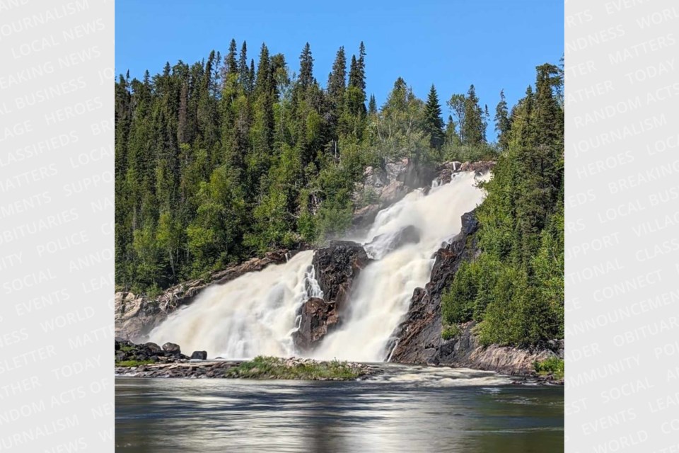
High Falls is a recent conquest as far as a sought-after destination. And it is not so difficult to access.
History
It was on the back roads’ list for more than a decade because of an outstanding information resource.
This treasure trove was first found on the Town of Manitouwadge website under waterfalls. When you click on the tab an older type of information .pdf guide emerges. You can tell by the font, the photo layout and description, there are no GPS coordinates
There are details, like no other…detailed driving instructions with homespun descriptions like, “…Follow for 7.5 KM (4.6 mi) to the shallow washout. Park and continue following the road through the washout taking the first trail immediately to the right just past the washout. Or, “…Take a right at the burned railway ties, (trail is flagged), follow trail for 0.1 KM (328 ft),” and “…being sure to stay on the main road by staying right. At the end of the road follow the game trail on the left side of road until you reach the falls.” .
And gems about another nearby waterfall. “…In the spring time during the spawn, you will also find rainbow trout in the Nama Creek. You can literally see them jumping the falls. Imagine watching a large number of fish jump out of the water trying to swim against the strong spring current?”
Scroll to the High Falls page! “Have a gander,” it is an old-fashioned informal saying akin to the resource. But Nature changes what was once easy to access.
The author
This led me to think again, twice thwarted, about how to get to High Falls. There was no author cited, who created this comprehensive guide? Back in the day it was an anomaly for northern Ontario tourism to have such guidance.
The same social media approach was utilized as per the swimming pool story, posts were made via Facebook on the Manitouwadge and Caramat pages. Through the diligence of group members Grant Goodwin, the guide’s coordinator was finally located.
The community, started in 1954, is one of two government-planned communities, most are planned by the corporate resource sector. The other is Elliott Lake. The Goodwin family moved to Manitouwadge in 1958, Grant’s dad worked at the Geco Noranda Mine.
In 1973 Grant was appointed as Director of Parks Culture and Recreation. As a community volunteer, he was deeply involved with what the Manitouwadge area had to offer naturally.
With the closure of two mines, “I began thinking of the future of our community, besides finding another mine what did we have? Were we prepared as we could be/should be? What exactly was out there, would people come to see it?
Grant says, “And it should be noted we are located pretty much on the top of the Height of Land.
With the support of The Local Citizens Committee, “as a volunteer, not as an employee,” says Grant, he made an application to the federal government for funding through a program that prepared people with the skills to enter the workforce. “We hired four staff, and opened a storefront office, as community involvement is always key to any successful project.” It took one year of fieldwork and project development to put together this resource. Grant is sending along one of the remaining CDs.
“There was resource binders CDs for everyone, tee shirts, hats, coffee cups, maps,” all highlighting access to the waterfalls, trails and canoe routes.
And he is still at it in his mid-seventies. He is presently gathering information on three potential projects, old bush Camps (Lumbering), erratics, and kettles lakes. “I pretty much work alone with a couple of friends that get dragged along.”
The 23-year-old resource guide has almost stood the test of time, read on.
River driver
“As you rabbit hop across the eight-foot pulp logs you have to make sure you step right in the middle of the next log you choose.”
That confidence comes from experience we cannot relate to. Roger McCraw is one of the last of the Pic “river log drivers. He has probably been to High Falls more than any one person in three capacities.
A member of Pic River First Nation he was born in nearby Stevens, now a CN railway ghost town and then moved to Caramat (south of Highway 11, east of Longlac) in 1958 and remained there most of his life working life. High Falls was “first place to go with my family.”
Like his father, he was a “bush worker” and “river driver.” In the spring during the “log drive” he used first wood and then aluminum pike poles and high-top rubber boots along with a rudimentary life jacket.
“Our job was to ensure that the logs floated freely all along the Pic river. There were typically two groups of men per crew. The more experienced and nimbler were in the jam or beat crew. When they spotted a jam, they tried to get to it quickly and dislodge the problem logs before a pileup or dam happened. Others would come along and direct the logs with the pike poles.” Longer days meant more hours of work and more money.
Long gone, you begin to realize these drivers understood physics, were fearless, strong, and extremely agile within the danger of this manual labor, unique job description.
“Working 24/7 we worked at the brink of the falls by the light of a small diesel generator to ensure there were no jams.” “Once,” he said, “someone sleeping on their shift caused a log jam going back ten miles upstream.”
He verified that a huge pinnacle type of rock was blasted away at the brink to allow the free flow of pulp logs eventually ending up in log booms, at the mouth of the Pic River, on Lake Superior bound for the mill in Marathon (Marathon Co. and then American Can., closed in 2009).
Then later in life he was a local entrepreneur. “It’s a gem that no one seems to know about,” he said. Roger used to take tourists, as a business enterprise, to High Falls for a picnic via ATV while towing a “rickshaw type of buggy for guests.”
He was the owner and “gas jockey” at the Texaco station and general store but he closed it about sixteen years ago. (Now it is a hunt and fishing camp with municipal services. Presently you can buy the vacated school for $150 000.
The two island pumps are long sealed but above the former store entrance it was noticed, a stylized logo of High Falls. It says “Quissy’s.” Roger says, “Within anishinaabemowin it roughly translates as “Sonny,” it is my Indigenous name. And the falls has always been the focal point of Caramat.”
Waterfalls of Ontario
If you are looking for waterfalls go to the definitive source, Waterfalls of Ontario website. In its 25th year, Mark Harris has been reaching out to “moving water enthusiasts” and mapping destinations. Here is the Back Roads Bill podcast with Mark.
“I think that there is real potential for waterfall tourism in the Manitouwadge area. There are some great spots! The road network would need some work to make the waterfalls accessible to more people. Perhaps the town can find some partners to make this happen.”
“I read that High Falls on the Pic was getting tough to visit. I have a Subaru Forester, which is no jeep, but it lets me go some places with safety and confidence. Sadly, it’s now ten years old and I am hesitating to venture too far “off-road”.”
Bryce Dubé is a local (since 2016) “waterfall chaser” who was with Mark Harris last year. “He came up last year as we did a semi-successful expedition,” but not to High Falls.
He said, “I would like to see more maintenance of certain trails to our hidden natural gems. Volunteer work would go a long way.
“During the summer I’m going to try and chart Four Bay Falls and log my actions as to update the directions. I may do the same for others in the area.”
His favourite is Manitou Falls (Pic River, below Middle and High Falls). “Because of the ease of access, it’s hidden location off the Pic River and the size of them compared to other falls.”
More
There is some video of the dynamic nature of High Falls.
First, from an Adam Shoalts type of adventurer - Jonathan Kelly.
He started up his video channel Lost Lakes—formerly Backcountry Angling Ontario in 2017 and captured on film his 95 days of solo canoe tripping. His YouTube channel has 388 videos and 299K subscribers.
Go to the 1:01:00 mark for High Falls footage - ‘A Powerful 200km Solo Wilderness Trip - Wildlife, Fishing, Fall Colours, and the Chill of Autumn. Great drone footage here and Jonathan says, “It’s hard to leave…lingering on …High Falls was worth the price of admission!”
Duncan Michano Chief of Pic River First Nation (he and Roger are cousins) pointed me to the documentary ‘Our River’ N'ziibiimnaan’. At the thirteen-minute mark, you can see some footage from the brink. It is a journey tracing traditional values and an important waterway used for seasonal foraging and trading.
Brian Emblin of Timmins was with Back Roads Bill. Of the experience, a few weeks back, “A bigger drop than Agawa Falls (Lake Superior Provincial Park, not seen from the excursion train) with a broad wide open face. There is easy access to both the top and bottom.
“Well…the photos of the log jams (Roger’s) are incredible after having been there and comprehending the scale of the jam and the volume of the wood put through that spot.
“It’s interesting,” Brian said. “We talk about rivers being used for transportation for the original peoples then for the fur trade but I never really thought too much about it that they were used for transportation for the traditional log drive.”
Here is the map. Your approach can be from Manitouwadge or Camarat, from Highway 17 or 11, existing access by vehicle with clearance is Carmat. Hikers, ATVs and mountain bikes can shorten their trip by fording Skunk Creek, off of the main industrial road, where the bridge was removed. It is not so difficult.
As others have experienced High Falls it will not disappoint. It is more than just the height and volume of water. So much to see, hear and feel on the back roads.


