In the past the idea was to just about dam everything.
Did you know they were going to create a sixth “man-made” Great Lake? Other than Lake Nipigon and beyond.
You always wonder who “they” are?
We don’t know much about “them,” but two other mega hydro projects did evolve, significantly raising the water level of the Great Lakes.
One of these projects is a water control dam much wider than the famed Hoover Dam on the border of Nevada/Arizona. The other scheme created an erosion-plagued reservoir twice the size of PEI.
Today they would never be allowed to occur. But “back in the day” it was in the name of economic progress and there were costs to pay socially and environmentally.
We don’t know much about these mammoth projects. For orientation first see the map to see where all of this happened. You can visit the water control dams, (two require more effort), and drive directly to the related damage firsthand.
And note the identified water control structures have no turbines for power generation. These dams – one each at the end of the reservoirs, strategically located by elevation - are like valves controlling much water flowing over the height of land south, and little water flowing north as it should naturally.
The source
Mega projects in northern Ontario.
The Great Lakes Water Wars, (Chapter Six) by Peter Annin has been called the definitive work on the Great Lakes water diversion controversy.
A veteran conflict and environmental journalist, Peter Annin spent more than a decade reporting on a wide variety of issues for Newsweek including the bombing of the federal building in Oklahoma City and the Branch Davidian standoff outside Waco, Texas. In September 2006, he published his first book on the Great Lakes.
He is now the director of the Mary Griggs Burke Center for Freshwater Innovation at Northland College, I reached him in Ashland, Wisconsin.
“Long Lake is no small diversion either.” Long Lake came first after Ontario made a Depression-era deal with four American paper companies to harvest trees in the surrounding watershed. The companies needed a dependable pulp supply; Ontario needed jobs for its citizens and revenue from natural resources.”
He said, “As for Long Lake damming the Kenogami River on the north side of Long Lake and blasting and cutting a channel on the south side, engineers managed to funnel the diverted water into the Aguasabon River, which flows into Lake Superior near the town of Terrace Bay, at roughly 1,500 cfs (cubic foot/second).
While construction on Long Lake was wrapping up, Canadian officials started talking about adding the larger diversion at Ogoki. The thinking behind Ogoki was very different, however, and much more urgent.
In 1939 Britain and Canada entered World War II, and Canada was desperate to boost its hydro capacity in order to power the war effort.
“Spanning 1,700 feet (518 m)—or more than five football fields it is more than 450 feet (137 m) longer than the Hoover Dam on the Colorado River. The Ogoki Reservoir is by far the largest inter-basin water transfer project ever built in the Great Lakes region.”
“When Ogoki and Long Lake are lumped together, they become huge—the equivalent of adding a large new river to the Lake Superior ecosystem. They not only raised water levels on Superior—the largest surface area of freshwater in the world—they also raised lake levels on every other Great Lake in the system. According to the International Joint Commission, Long Lake and Ogoki have boosted Lake Superior water levels by 2.4 inches (7 cm).” That is significant. He said, “No one envisions diversions like Long Lake and Ogoki ever happening again.”
Erosion examples
Because of the above, there are two legacy examples of significant erosion attached to these two water diversion schemes created by Ontario Hydro - Ontario Power Generation (OPG).
The Ogoki diversion caused a significant loss of shoreline on Lake Nipigon. See this find - 1923 lifestyle on Lake Nipigon - the landscape was to be entirely changed forever.
Whitesand First Nation (FN) was located on the northwest side of the lake and lost its entire reserve, they had to move towards Armstrong.
Whitesand members were without a permanent home until a new reserve allotment was agreed upon in 1977, some 40 years after the diversion flooding began.
The following was a serendipitous contact. A teenager in 2015 Darian Doblej, was a summer student - Community Liaison Officer for Whitesands FN at the most northwestern shore of Lake Nipigon. In 2009, OPG agreed to about $12.5 million in compensation for the displacement damages.
At the time he helped gather erosion information.
A member of the FN, he is now a lawyer.
“I understand that the erosion of the Whitesand First Nation community of “Old Whitesand” was caused by various OPG legacy projects and was subject to a court claim by Whitesand alleging the same (see the Generating Power subsection below). I understand this claim settled out of court and resulted with OPG paying for the stabilization of the shoreline.
You can see the 2004 citation - Whitesand First Nation v. Canada (Attorney General), 2004 CanLII 36098 (ON SC).
Within the document, “This action deals generally with alleged losses and damages sustained by the Whitesand First Nation and Red Rock First Nation Band of Indians (“Whitesand” and Red Rock”) associated with the construction of various Hydro projects located in the Nipigon watershed.”
“The effects of the Hydro projects had and continue to have negative impacts on the way of life of the Ojibwa people, and the Plaintiffs see a remedy in relation to the losses they suffered to their way of life in general, and to the specific aspects of social, cultural, spiritual, political and economic benefits as alleged in the claim.”
An international engineering group Baird and Associates was retained to mitigate the shoreline. The project is now complete and continues to be monitored. The solution consisted of a 1400-metre-long revetment and grading to a stable slope. The slope was vegetated with native species and livestakes (inserted stem cuttings). A 2.7 km access road was constructed to provide improved access to the shoreline that helped reestablish “OId Whitesand.” (I have seen it, and it is worthwhile seeing how a wrong can be mitigated, albeit long after the fact.)
So when you cross the new cabled Highway 11/17 highway bridge or visit the OPG Alexander G.S. designated visitor overlook, north of the Town of Nipigon on Highway 585, consider the Ogoki River diversion and its historic-social effects to Lake Nipigon.
Long Lake
Look at an Ontario road map. Find Longlac and Terrace Bay connected by Long Lake one the longest by name in the province, in essence, it is a turbid reservoir (92 km or 57 miles).
The possibility of diverting James Bay runoff into the Great Lakes emerged in the 1920’ and 30’s during surveys of another transcontinental railway.
The Long Lake Diversion was a method of providing employment, opening up a scarcely settled part of the province, and harvesting the virgin forest resources.
A consortium of paper firms, signed an agreement to construct the project in 1937.
The entire north end of Long Lake suffered erosion from the Ogoki diversion.
The Long Lake Diversion was constructed in two phases. The first of these, completed in 1939, redirects the discharge of a tributary of the Albany River, the Kenogami, south through Long Lake via an interbasin diversion canal into the Aguasabon River that empties into Lake Superior.
To prevent and reverse northward Kenogami River discharges, the Kenogami River Control- Dam was constructed 10 miles (16 km) north of Long Lake (Longlac-Blueberry Rd.).
At the south end of the lake, a 5-mile (8 km) diversion canal was excavated through the height of land. The end of the canal the South Regulating Dam was erected to govern southward diversion flows into the Aguasabon River and the Great Lakes.
The two dams control a diverted watershed of 11 630 square miles or 30 121 km-squared – twice the size of PEI.
The Long Lac diversion eroded the small tract of land held by Long Lake #58 FN since 1905. It flooded 142 acres (57 ha) of the reserve, leaving about a square mile for the 1,200 members.
OPG, first placed mine waste and mine blast rock along the shoreline when Ontario Hydro (OPG) installed the rip rap in the mid-1970s.
In 2006, the province-owned company took full responsibility for injury caused by the diversion and made a multi-million-dollar payment to address long-held First Nations grievances.
From the Long Lake #58 FN website: “As a result of our negotiations with OPG from 2007-2010, our First Nation has been in control of the remediation project along the shoreline to repair the environmental damage along the shoreline and to protect our members from any potential contaminants that still exist,” (from the 1970’s).
After the First Nations membership voted overwhelmingly to accept the environmental settlement with OPG, work was able to begin on the project. In 2011-2012 most of the site preparation work was initiated with trees being cleared, trails prepared and access to the waterfront areas began to take shape.
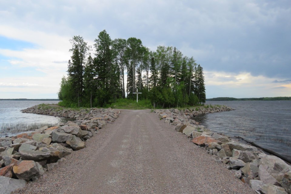
In the cemetery, you can see the white cross. It is off Highway 11, just east of Long Lake #58 General Store and gas bar, and it is a stark reminder of the diversion’s effects. Many of the graves washed away before the OPG placed barriers to stop erosion. What remains of a former raised peninsula is now an island. (Same with the very visible Church Point, just east of the cemetery.)
The Aguasabon Falls and gorge is a stunning, must-see attraction in Terrace Bay on Highway 11, not so natural. The water here soon enters Lake Superior, but from the safety rail, through the mist, when you peer at its wonder think about the Long Lake diversion project and its social impacts.
Generating power
Power generation was the order of the day, post water control diversion projects.
For the record, there are four dams (three are power) on the lower end or south end of Lake Nipigon and the Nipigon River.
The Cameron Falls Dam on the Nipigon River was built in 1918. In 1925 and 1930 two more dams, the Virgin Falls and the Alexander Dams were built "to enable the total flow of the Nipigon River to be utilized for power development"
Virgin Falls, was built in 1925 to control water levels on Lake Nipigon. This dam created the largest reservoir in existence and raised Lake Nipigon by 15 cm (0.48 ft). The Ogoki River Diversion was initiated in 1940. From the Brook Trout Heaven website, “The Ogoki Diversion on the Ogoki River raised the lake level by 35 cm and increased the flows by 50% in the Nipigon River.
The existing power plants on the Nipigon River could not effectively harness this increased output, so the Pine Portage Dam was built in the 1950s and it too raised the water level of Lake Nipigon by 12 cm, flooding over the Virgin Falls Dam.
The completion of the Pine Portage Dam in 1950 raised the water level on the Nipigon River by 31 metres (100 feet) and flooded out almost 16 kilometres of white water, rapids and waterfalls including the White Chutes, Victoria, Canal, Devil, Rabbit and Miner’s Rapids. Lake Emma and Hannah were both flooded out and the whole area was renamed Forgan Lake.” That’s an accumulative impact making Lake Nipigon a reservoir as well.
At the lower end of Long Lake at Terrace Bay, the beginning of Terrace Bay (classic heritage marketing film of the day) was initiated with a new pulp and paper complex. The diversion project (at Long Lake) had been completed 10 years earlier.
The hydroelectric power derived from the Augasabon Generating Station, started in 1946, meant that the growing industrial demands of the area—mainly the new mill of the Long Lac Pulp and Paper Company, later the Kimberly-Clark Pulp and Paper Company—could be met. Power was also supplied to the Thunder Bay area via a 110,000-volt steel transmission line.
On hold, today, there remains a proposed https://www.ontarioriversalliance.ca/lower-lake-hydro-project-augusabon-river/ Lower Lake Hydro Project – Augusabon River, 16 km north of Terrace Bay by Brookfield Power and Pays Plat FN and Ojibways of the Pic River First Nation. At present the mill at Terrace Bay is closed.
Sixth Great Lake
It was widely reported in the 1920s, by at least three engineers, they hatched a seemingly unbelievable scheme 100 years ago. It was Hoover Dam thinking.
RH. P. Ramey, a Chicago sanitary engineer, Lorne Campbell and Ralph Keemle, two Canadian railway engineers all purported a sixth Great Lake northwest of Lake Nipigon. Although not hydrologists “they” conceived two dams on the Albany River and then let it overflow its river banks, reversing its flow through Lake Nipigon. “They” said it was a low-lying ready-made basin.
The Albany River, 982 km long, is the second longest and largest river in Ontario. It issues from the northwestern part of the province and on its eastward course to James Bay. Like the Mackenzie River, it flows through a network of interconnected lakes on the Canadian Shield above the Great Lakes Height of Land. The familiar Kenogami and Ogoki Rivers are its two main tributaries. The Albany River has a drainage basin of 135 200 km2. The lake would have been two and one-half times larger than Lake Ontario. Their conceptual thinking was correct, the Arctic (James and Hudson Bays) watershed is within a short distance of Lake Nipigon which empties into Lake Superior and beyond.
At the time there was no mention of the many traditional First Nation communities attached to the Albany River. It was not an unpopulated landmass.
Contemporary
“They” (we) are still damming rivers.
Today there are cooperative ventures with First Nations communities such as New Post Falls, which was one of the first.
And OPG continues to explore old and new possibilities. The Little Jackfish River, which flows out of the same Ogoki Reservoir is the most advanced of medium-scale hydroelectric projects in northern Ontario.
This article says, "Significant investment of time and resources has been made towards completing the environmental assessment process, as well as a shared equity partnership between OPG and six Lake Nipigon First Nations.” Other power dams are needed for the Ring of Fire mega mining development.
OPG has identified the potential for new hydroelectric developments including a number of sites on the Upper Albany and Attawapiskat Rivers
And in passing let us not forget there were other diversions like the Black Fly Song story a few weeks back where the Little Abitibi River was diverted from its intended course.
There is always change. In these two cases who knew what was?
When you drive the back roads, you have to keep more than your eyes open for moose sightings and those numerous black bears. Be mindful of the past and the future.


