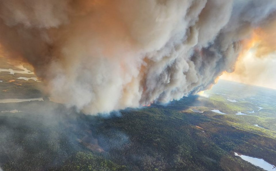
Lake Abitibi-area fires are creating significant smoke impacts, says Aviation, Forest Fire and Emergency Services (AFFES).
Two fires started north of Abitibi Lake yesterday. In a tweet, AFFES said the smoke is impacting residents in the area. As of last night (June 2), the agency reported that the large fires were "exhibiting extreme fire behaviour" and being closely monitored.
A special air quality statement remains in effect for Timmins, Cochrane and Iroquois Falls due to the high levels of air pollution from the forest fire smoke.
In total, eight new forest fires were confirmed Friday in northeastern Ontario, bringing the total to 20 in the region, according to AFFES.
- Wawa 5 is 0.1 hectares and not yet under control. The fire is located about 1 km south of TransCanada Highway 17 and 20 km northwest of White River.
- Algonquin Park 3, 4, and 5 are each 0.1 hectares and not yet under control. These fires are located between lakes Lavieille and Opeongo in the central area of Algonquin Provincial Park.
- Cochrane 6 is 1000 hectares and not yet under control. The fire is located about 11.6 km west of the northern end of Lake Abitibi and 31.6 km northeast of Iroquois Falls. This fire is exhibiting aggressive behaviour and action plans are being formulated.
- Cochrane 7 is 600 hectares and not yet under control. The fire is located about 16.8 km northeast of the northeastern end of Lake Abitibi and 11.2 km west of the Quebec border.
- Chapleau 4 is 0.4 hectares and not yet under control. The fire is located about 34 km west of Highway 144 or 3 km west of the south end of Opeepeesway Lake.
- Sudbury 6 is 0.5 hectares and not yet under control. The fire is located about 14.5 km northwest of Windy Lake and about 3 km west of Highway 144.
Including new fires, there are currently 20 active fires in the Northeast Region:
Fires currently under control include Hearst 3 at 0.7 hectares, Cochrane 2 at 0.4 hectares, Sudbury 5 at 1 hectare, and Kirkland Lake 2 at 2 hectares.
Fires being held include Wawa 2 at 105 hectares, Timmins 6 at 8.5 hectares, and Kirkland Lake 3 at 2 hectares.
Fires currently not yet under control include Cochrane 3 at 80 hectares, Cochrane 4 at 1 hectare, Cochrane 5 at 5 hectares, and Chapleau 3 at 20 hectares.
Fires being observed include Cochrane 1 at 45 hectares.
Fires of note:
Wawa 3, which began on May 27, is not yet under control and remains at 6,810 hectares. An Incident Management Team is established and suppression is ongoing.
Travel and use Restrictions in the Northeast Region - MNRF Chapleau-Wawa District:
Under the Emergency Area Order EAO-2023-01 declared on May 31, 2023, the Ministry of Natural Resources and Forestry, Chapleau-Wawa District has put in an Implementation Order for the WAW003 fire to protect public safety and to facilitate effective fire suppression.
The following restrictions listed below and as outlined on the Implementation Order Map, remain in effect until further notice.
All travel and use of the following areas is prohibited unless you have a travel permit issued by the Chapleau-Wawa District Ministry of Natural Resources and Forestry (MNRF):
- 400 south of where Road 400 intersects the White River Forest Unit boundary
- Road 300 south of the intersection of Road 300 and Road 350
- Road 500 west of the intersection of Road 500 and Road 550
- Road 226 west of the intersection of Road 226 and Highway 631
- Mink Lake East Road north of intersection of Mink Lake East Road and Highway 631
- Mink Lake Boat Launch Road north of intersection of Mink Lake Boat Launch Road and Highway 631
- Operational Road 631-02 north of intersection of Road 631-02 and Highway 631
- Operational Road 631-01 (aka. Tower Road) north of intersection of Road 631-01 and Highway 631
- Road 100 north of intersection of Road 100 and the Picnic Lake Road
- North Reagan Road north of intersection of North Reagan Road and Road 50
For a closer look at fire hazard conditions in your area, view this Interactive Map.