There are new travel restrictions in place due to two fires burning in the Lake Abitibi area.
Both fires have been burning since late last week, with the Ministry of Natural Resources putting an order in place to prohibit travel where the fires are active or there is fire suppression work being done. The order was effective as of 7 a.m. this morning.
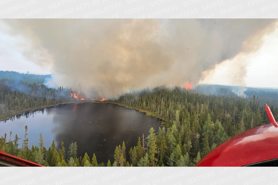
"Due to extreme fire behaviour in the area North of Abitibi Lake, some residents ahead of the Cochrane 7 wildland fire in the Eades township were advised to leave the area as a safety precaution. Cochrane 7 is currently 1,840 hectares and not under control. It exhibited high to extreme fire behaviour in recent days," said Shayne McCool, Aviation, Forest Fire and Emergency Services (AFFES) fire advisor.
There are 10 active fires not under control in the area in the Chapleau, Timmins, Cochrane and Hearst districts.
- Chapleau 3 was remapped yesterday to 500 hectares and is about 53 kilometres south of Highway 101 and 67 kilometres east of Highway 129. AFFES said on Twitter that the fire behaviour and smoke has made it difficult to get FireRanger crews on the ground.
- Chapleau 6 is 210 hectares and is located 48 kilometres northwest of Chapleau and 15.7 kilometres west of the southern point of Missinaibi Provincial Park. AFFES has not flagged any concerns with it at this time and is carefully monitoring the fire.
- Cochrane 3 is 80 hectares and not under control. It is located between Cochrane and Iroquois Falls.
- Cochrane 5 is five hectares.
- Cochrane 6 is 1,239 hectares. It is located about 11.6 kilometres west of the northern end of Lake Abitibi and 31.6 kilometres northeast of Iroquois Falls.
- Cochrane 7 is 1,840 hectares and is located about 16.8 kilometres northeast of the northeastern end of Lake Abitibi and 11.2 kilometres west of the Quebec border.
- Cochrane 8 east of Cochrane off of Highway 652 is 35 hectares and seeing increased fire activity.
- Cochrane 9 is five hectares.
- Hearst 4 is 12 hectares
- Timmins 7 is 120 hectares. It's located between Highway 101 and Highway 144.
Yesterday, Mattagami First Nation residents were asked to pack a bag and be on standby for a possible evacuation due to Timmins Fire 7.
SEE: Forest fire puts community on standby for possible evacuation
Timmins 6, which was in the Malette Road area, is now listed as being out. Timmins 8 is 0.8 hectares and listed this morning as being held. It's located two kilometres west of the Akonesi Chain of Lakes Complex and 0.8 kilometres south of Brady Lake.
For other active fires, Chapleau 7 is one hectare and under control. Cochrane 1 is 45 hectares and being observed, and Cochrane 2 is 0.4 hectares and under control.
Travel Restrictions
As of this morning (June 6) at 7:01 a.m., there are new restrictions in place where there are active fires and fire suppression happening for the Cochran 6 and 7 fires. Under this new implementation order, travel is prohibited in the following areas unless you have a travel permit issued by the Hearst-Cochrane-Kapuskasing District Ministry of Natural Resources and Forestry office:
- Translimit Road eastwards beginning where it intersects with the Northwest Industrial Road
- Translimit Road west of the Ontario-Quebec border
- Northwest Industrial Road north of the Abitibi bridge
A map of the restricted areas is available here.
The travel restrictions put in on June 3 remain in place. It prohibits travel in the following areas:
- Reaume Esker Road beginning where it intersects with Town Dump Road
- Potter Road West of the TC Energy Plant
- Connaught-Evelyn Road North of the Pallet Lake access point
People requiring travel permits should contact the district MNRF office at 705-272-7178 or email [email protected]. A map of the restricted areas is available here.
There are also restrictions in the Chapleau-Wawa District under an order issued on May 31. It prohibits travel in these areas:
- 400 south of where Road 400 intersects the White River Forest Unit boundary
- Road 300 south of the intersection of Road 300 and Road 350
- Road 500 west of the intersection of Road 500 and Road 550
- Road 226 west of the intersection of Road 226 and Highway 631
- “Mink Lake East" Road north of intersection of "Mink Lake East" Road and Highway 631
- "Mink Lake Boat Launch" Road north of intersection of "Mink Lake Boat Launch" Road and Highway 63
- Operational Road 631-02 north of intersection of Road 631-02 and Highway 631
- Operational Road 631-01 (aka. Tower Road) north of intersection of Road 631-01 and Highway 631
- Road 100 north of intersection of Road 100 and the Picnic Lake Road
- North Reagan Road north of intersection of North Reagan Road and Road 50
- Road 10 east of intersection of Road 10 and Highway 17
- Road 99 east of intersection of Road 99 and Highway 17
- Operational Road 631-05 east of intersection of operational Road 631-05 and Highway 631
A map of the restricted areas is available here. For a travel permit in these areas, contact the Chapleau-Wawa District Office at 705-856-2396.
The northeast region continues to be a restricted fire zone and no open-air burning is allowed.